National Register of Historic Places in San Francisco
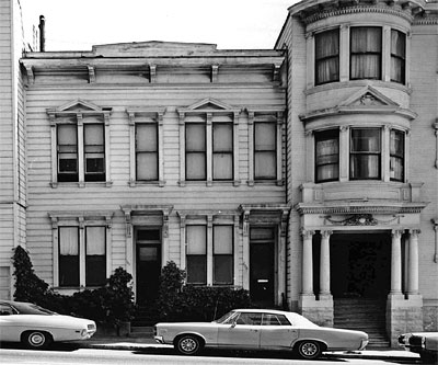
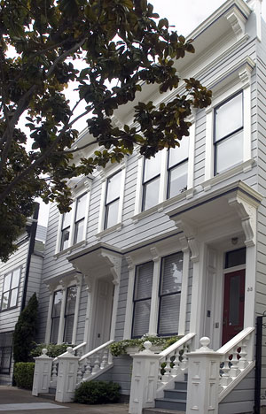
Building at 33-35 Beideman Place
33-35 Beideman Place Between Ellis and O'Farrell
Built Around 1876
The Italianate two-family residence which now stands at 33-35 Beideman Place was moved here from 736-738 Franklin Street.
In the early 1970's, the San Francisco Redevelopment Agency razed much of the Western Addition, a 19th century residential neighborhood regarded as a slum. A few vintage buildings were saved by private buyers.
The following is excerpted from the 1973 NRHP Nomination Form :
The San Francisco Water Department records show that 736-738 Franklin Street was connected to the water system in 1876. The Junior League of San Francisco's book Here Today concurs with this date and goes on to say, "the façade of this flat front Italianate is broken up by more doors and windows than usual."The original owner was Henry Vollmer. He lived a few doors away and rented this property out as an absentee landlord and owned the building until 1894. (Vollmer's home was moved to Webster Street.) After that there were three absentee owners until the San Francisco Redevelopment Agency bought it in 1967.
Although this building was owned by absentee landlords, it has been kept in good condition both inside and outside. This Victorian is to be moved to become one of a row of lovely Victorians on Beideman Place near Ellis Street.
This Victorian survived the 1906 earthquake and fire.

- 33-35 Beideman Place
- 45-57 Beideman Place
- 1840-1842 Eddy Street
- 1239-1245 Scott Street
- 1249-1251 Scott Street
- 1321 Scott Street
- 1331-1335 Scott Street
- 1815 Sutter Street
- 1735-1737 Webster Street
The following is excerpted from the NRHP Nomination Form for 33-35 Beideman Place:
Because of the zoning within the project area, this building has to be either demolished or moved to a more suitable location where it can be rehabilitated and preserved.This will be one of eight buildings to be moved onto a two block development within the Western Addition. These two city blocks will be intensively developed with projects including scattered public housing, moderately priced private housing, private rehabilitation and rehabilitation for public bidding and resale by the San Francisco Redevelopment agency. A few rehabilitation projects have already been completed within these two blocks.

Consider Highclere Castle (Downton Abbey). Lovely building.
Consider the Taj Mahal, the Doge's Palace, the Parthenon, the Lincoln Memorial, the Sagrada Familia, the Winter Palace of the Tsar, the Hagia Sophia, San Francisco's own City Hall and Opera House and Legion of Honor.
Lovely buildings, all. Essential to their appeal is that they stand unobstructed to be admired from any angle and at any distance.
Over the past twenty years or so, many of San Francisco's most distinctive buildings have gone into hiding behind ill-considered street trees. Except for the Spreckels Mansion Spite Hedge which clearly flips the bird to San Francisco, most of these trees were planted in good faith to beautify the streetscape, filter the air, increase property values; but like the cute SPCA puppy who grows up to be a two hundred pound mastiff, many of our street trees would be more at home in the country than the city.
Here is a short list of some striking San Francisco buildings which I wish were more clearly visible. I'm sure the Hop-On Hop-Off tourists would enjoy them too. They can see an ineptly pruned ficus or an ailing plane tree anywhere.

