National Register of Historic Places in San Francisco
 4 February 2012
(Click Photo to Zoom)
Gold Rush Ship in Levi's Plaza
AKA Frederick Griffing's Ship
Levi Plaza on Battery Street
This wooden hulled packet ship, built in 1827, was sunk in 1852 for use as a wharf. The hulk is buried beneath Battery and Greenwich Streets in San Francisco. Privately owned. Listed in the National Register as nationally significant.
National Park Service Abandoned Shipwreck Act Guidelines

1978 In late April 1978, remains of a ship's hull was discovered during excavation for Levi's Plaza. The vessel was estimated to be about 100 feet in length and 30 feet abeam. Historians believed that the ship was either the Palmyra or the William Gray. Archaeological excavations, financed in part by Levi Strauss, were conducted in late 1979 and early 1980. Although plans were drawn for a visitor's exhibition of the ship, they never materialized, and she still lies beneath the plaza.
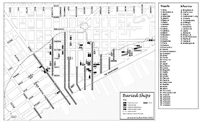
Ron Filion has drawn a fascinating map comparing the shoreline of San Francisco at the beginning of the Gold Rush to the shoreline today. The map shows the resting places of the many piers and ships buried beneath the Financial District and the North Waterfront.
Mr. Filion's San Francisco History website is an excellent resource for students of San Francisco histroy.