San Francisco Landmarks
Hanson House
126 27th Avenue Between Lake and El Camino Del Mar
Built 1907
Statement of Significance
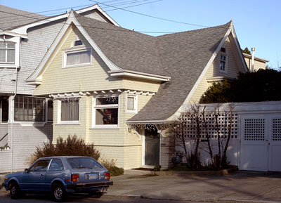
One of the first houses built in the middle Richmond District is the Hanson house, an outstanding early example of the shingle style with numerous flared edges and a complex roofline featuring cross gables and a ski-slope side gable.
Architect John Charles Flugger was closely identified with the Richmond District. He grew up on Point Lobos Avenue - later renamed Geary Boulevard - between Arguello Street and Second Avenue. His father owned a dairy at Point Lobos and Tenth Avenue. Another relative ran a saloon in the neighborhood.
The house is also significant as an early structure built on land which was undivided and undeveloped until the beginning of the 20th century. Its first owner was master mariner Alfred G. Hanson, an instructor at the US Naval Training Station on Yerba Buena Island from 1903 to 1908.
Adapted from City Planning Commission Resolution 7566 dated September 30, 1976.

The first verifiable resident of the Baker Ranch tract was John H. Baker, proprietor of the Golden Gate Dairy Ranch.
Baker died in 1863, leaving the land to his widow Maria and six children. An Act of Congress in 1866 gave San Francisco clear title to property within the city limits, and on 9 December 1872, the Outside Lands Committee confirmed Maria's title. As late as the Block Book of October 1901, the tract, which included Sea Cliff, was listed in acres, not blocks and lots. Alfred G. Hanson bought two lots in 1904-05, and built his first residence at 120 27th Avenue, probably completed just before the Earthquake of 1906.
Little took place in the vicinity of the Baker Ranch to disturb its serenity until after the beginning of the 20th century. Early maps refer to the Richmond and Sunset Districts as Great Sand Wastes. Until the last quarter of the 19th century even the inner Richmond was without water systems, sewers, lighting, street grading, and fire protection.
The middle and outer Richmond remained an area of horse and cattle raising and amusements such as race tracks. The main deterrent to development was perceived to be the cemeteries clustered around Lone Mountain. One of the most insistent voices for the removal of the cemeteries was J. H. Bond, editor of the Richmond Banner, who in 1894 repeated the common belief that cemeteries "plant germs of disease in the organs of breathing life." In 1900 the Board of Supervisors passed an ordinance prohibiting further burials in the City, but the last two cemeteries were not completely removed until 1940.
Although John Brickell began to sell his properties as early as 1904, it was the 1906 Earthquake, and perhaps the recognition that the cemeteries were to be removed, that led to development of the Richmond. Earthquake refugee camps had also introduced the area to many. However, by the second decade of the 20th century, the middle and outer Richmond were still sparsely built up.
Adapted from City Planning Commission Resolution 7566 dated September 30, 1976.
