NoeHill Travels in California
Historic Sites and Points of Interest in Sutter County

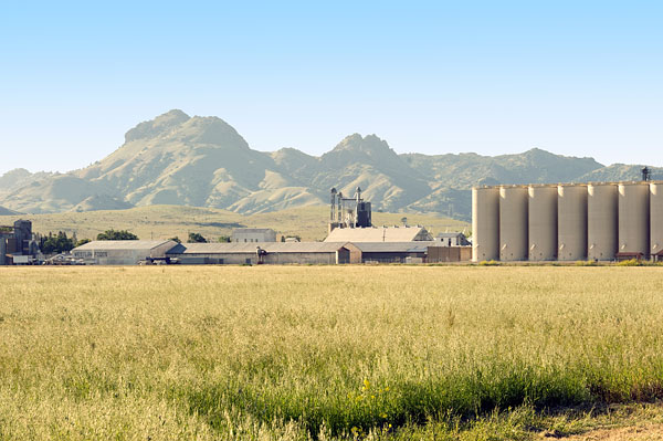
Sutter Rice Company and Sutter Buttes
2 May 2010
(Click Photo To Zoom)
Sutter County, named after John Sutter, lies in the heart of the agricultural Sacramento Valley forty miles north of the city of Sacramento.
Vast tracts of rice, almonds, walnuts, prunes, peaches, wheat, and row crops are irrigated by the Feather, Yuba and Sacramento Rivers.
Except for the Sutter Buttes and the grain storage silos, Sutter County is absolutely flat. On a clear day, you can see the Coastal Range to the
west and the Sierra Nevada to the east.
The 2010 Census counted 94,737 people in Sutter County with 64,925 (68.5%) residing in the county seat, Yuba City.
| Name | Address | City | Year | Authority | ID | Sort Address | Sort Name |
|---|---|---|---|---|---|---|---|
| Fremont Expedition | Pass Road East of Kellogg Road | Sutter | POI | Pass | Fremont Expedition | ||
| Hock Farm Marker | US 99 at Messick Road | South of Yuba City | 1841 | California | 346 | 099-00 | Hock Farm Marker |
| Hock Farm Site | Garden Highway at Messick Road | South of Yuba City | 1841 | POI | Garden | Hock Farm Site | |
| Live Oak Historic Commercial District | Broadway Between Pennington and Elm | Live Oak | 1878 | National | 1997001657 | Broadway 01 | Live Oak Historic Commercial District |
| Live Oak Railroad Depot | Broadway at Elm | Live Oak | 1876 | POI | Broadway 00 | Live Oak Railroad Depot | |
| Masonic Temple Corner Stone | 2nd Street and B Street | Yuba City | POI | Street 02 | Masonic Temple Corner Stone | ||
| Mosburg Building | 739 Plumas Street | Yuba City | POI | Plumas | Mosburg Building | ||
| Sam Brannan Park | Gray Avenue in Sam Brannan Park | Yuba City | 1849 | POI | Gray | Sam Brannan Park | |
| Teegarden House | 731 Plumas Street | Yuba City | POI | Plumas | Teegarden House | ||
| Thompson Seedless Grape Site | 9001 Colusa Highway | Sutter | 1875 | California | 929 | Colusa | Thompson Seedless Grape Site |