San Francisco Historic District
) 25 May 2008
25 May 2008
)
) The building at 945 Battery Street was built in 1903. It was rebuilt in 1911 and the third story was added in 1916. It originally housed the Ciocca Lombardi Wine Company and later housed a fruit cannery.
The building at 945 Battery Street was built in 1903. It was rebuilt in 1911 and the third story was added in 1916. It originally housed the Ciocca Lombardi Wine Company and later housed a fruit cannery.
27 April 2023
) 945 Battery Street
945 Battery Street
27 April 2023
) The 19th century commercial brick building at 1025 Battery Street was originally occupied by George Howes, who operated a dispatch line of clipper ships.
The 19th century commercial brick building at 1025 Battery Street was originally occupied by George Howes, who operated a dispatch line of clipper ships.
27 April 2023
(Click Photos to Enlarge)
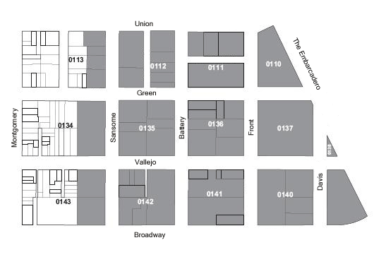
Bounded by Greenwich Street, Embarcadero, Montgomery Street, and Broadway
Designated in 1983
The Northeast Waterfront Historic District contains warehouses that were in continuous industrial use from the Gold Rush to the mid 1960's. Since then, office and retail uses have been integrated into renovated warehouse structures.
The district contains commercial warehouses from nearly every decade of San Francisco's history. The buildings range in age from the early clipper ship warehouses of Scotsman Daniel Gibb in the 1850s to the properties owned by the General Engineering and Drydock Co., a company crucial to the shipbuilding effort that made San Francisco Bay the major Pacific maritime support facility during World War II.
Because warehouse architecture did not undergo profound stylistic changes until the introduction of reinforced concrete, brick warehouses built after the 1906 Earthquake and Fire embody the original appearance and spirit of the 19th century warehouse district.
Of particular note is the block bounded by Front, Battery, Union, and Green streets, the most cohesive extant brick warehouse complex from this era in the City. In addition, cobblestone paving and the standard and narrow gauge belt line railroad track which served the district are visible at the foot of Commerce Street. The area clearly serves as a visual reminder of San Francisco's earlier maritime-warehousing commerce.
The original shoreline of Yerba Buena swept in a curve from Montgomery Street to roughly Jackson Street and on to the deeper waters slightly east of Battery. This point was known as Punta del Embarcadero. The cove itself fronting on the settlement was shallow and could be navigated only by small craft of shallow draft.
The historic district boundary begins at what was the site of the first deep water landing in San Francisco at Clark's Point. The first vessel to moor at a wharf tied up at this site and discharged cargo in 1848. The first Pacific Mail steamer to arrive in San Francisco disembarked passengers in this area in 1848 and the unique clipper ships built expressly for San Francisco's Gold Rush trade docked in this area in large numbers.
During the Gold Rush era, the boundaries of the area were extended eastward by landfill into the Bay in order to create new warehousing space. Large sections of Telegraph Hill were excavated for the fill. In the late 1880's a sea wall was built which settled the eastern boundaries of the area.
The clipper ships of the Gold Rush era and paddlewheel steamers of the delta and river trade docked alongside its wharves discharging a multitude of cargo, much of which passed through local warehouses. In the 1880's and 1890's large numbers of iron-hulled square riggers were involved in hauling grain From California's Central Valley to European markets. The new transcontinental trains were loaded on barges from the other inside of the Bay and were docked and discharged in this area. A number of ships are presumed to have been buried beneath the fill used to extend the district. A ship buried in 1851 as an extension of Frederick Griffing's wharf was recently unearthed during the excavation for Levi's Plaza on the northern boundary of the district.
Many distinguished San Francisco names and firms have been associated with the warehouses in the area: William T. Coleman head of the Vigilante Committee; George Howes, operator of clipper ships; Daniel Gibb, builder of the earliest warehouses in the area which were bought in 1861 by John Sanborn; Charles Minturn, steamboat tycoon; Isaac Friedman, the "Wheat King"; and Samuel Haslett, founder of a leading warehouse firm in the Bay Area.
Pioneer firms such as American Bisquit Co., Cowell's Lime and Cement Co., W.P. Fuller Co., the Petri Italian-American Cigar Co., and the California Fruit Packing Co., have major extant structures in the area.
After 1906 firms such as Bemis Bag Co., National Ice and Cold Storage, Cudahy Meat Packing, Armour and Co., Ciocca-Lombardi Wine Co., and the Italian-American Canning Co. located in the area.
In the 1920's and 1930's the Sunset Press, Security Lithograph, and various typography and lithography operations were set up in the district, reflecting the increasing importance of this industry in San Francisco's economic development. In 1940 General Engineering and Drydock marshalled a number of buildings for ship repair and maintenance during World War II.
Adapted from San Francisco Planning Code: Article 10, Appendix D.